
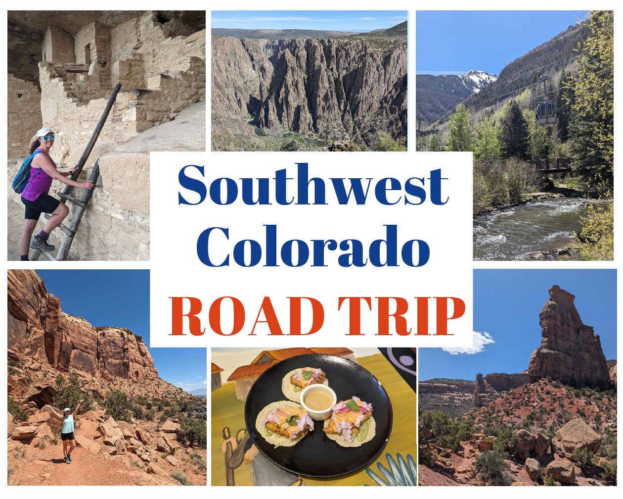
A Hiker’s Southwest Colorado Road Trip
This post contains affiliate links. That means I may earn a small commission at no extra cost to you, if you buy through my site. I appreciate your support of my site.
Wouldn’t it be nice to hike amongst red rocks, along canyon rims, up mountain peaks, and down to ancient cliff dwellings all in one trip? Look no further than Southwest Colorado! On this Southwest Colorado road trip you’ll hike through diverse scenery and terrain in just one trip!
Follow this Southwest Colorado road trip to discover the best hikes in western Colorado. Plus find out what else to do, where to eat, and where to stay.
This Southwest Colorado road trip follows a one way route from Grand Junction to Cortez. Check the FAQs at the end of the post for transportation options and ways to extend your road trip.
A Hiker’s Southwest Colorado Road Trip
Grand Junction

Anyone passionate about outdoor adventures will love Grand Junction. With red rock scenery, alpine lakes, mountain peaks, and flowing rivers, this small city is surrounded by nature’s best offerings!
Where to Hike Near Grand Junction
Colorado National Monument

If you’re like me and can’t get enough of red rock landscapes, you’ll love Colorado National Monument. The scenery is very similar to Moab just across the border in Utah, but this area receives significantly less visitors.
This is a national park site with a paid admission that is included with an America the Beautiful pass. Don’t let the “monument” in the name fool you. This isn’t some big marble monument that you would find in Washington DC. Referred to as a “mini-Grand Canyon”, the red rock canyon is full of interesting shaped monoliths. It’s not what you would expect to find in Colorado! It’s the first of many interesting landscapes along this Southwest Colorado road trip.
The 23 mile Rim Rock Drive offers breathtaking views from your vehicle and overlooks. Many trailheads to begin your journey along the rim or deeper into the canyon are located along this drive. The route goes from Fruita to Grand Junction.
Stop at the Saddlehorn Visitor Center, closest to the Fruita entrance, to watch the park film, learn from the exhibits, talk with park rangers, and peruse the gift shop. Water fountains are available 24/7 and restrooms are open during opening hours.
The Alcove Nature Trail and the Canyon Rim Trails are easy trails that begin at the visitor center. The Rim Trail is an awesome way to see sweeping views of the canyon.
Along Rim Rock Drive, Otto’s Trail is short and easy, but has excellent views from the overlook. The Devil’s Kitchen Trailhead has a variety of trails to choose from including one to a small cave, another to waterfalls, one with a bit of climbing…..and all with excellent views!

Monument Canyon Trail is a hard 11 mile out and back hike from Rim Rock Drive or a point to point hike (if you have two vehicles) between Rim Rock Dr & CO – 340. We hiked a portion of the trail, the Monument Canyon & Wedding Canyon Loop from CO-340. We hiked it counterclockwise (to the right at the junction) to save the magnificent Monument Canyon views for the last half. This also helped to have a harder ascent and an easier descent. The scenery is great throughout the whole trail and you’ll hike past the famous Independence Monument, along with other striking features.
Several other trails are marked on the map above for your convenience.
McInnis Canyons National Conservation Area
Arches NP in Utah is rightfully well known for hundreds of natural sandstone arches. The Black Ridge Canyons Wilderness within the McInnis Canyons National Conservation Area area is home to the second largest concentration of arches! Rattlesnake Arches Trail is a remote trail with 35 arches. You’ll need a 4 x 4 to reach the trailhead or need to hike 15 miles round-trip.
Rabbit’s Ear is another recommended trail with impressive views that usually isn’t crowded. The recreation area has plenty of other trails for hiking, horseback riding, motorcycle, and ATV trails as well as the Colorado River which attracts water sport enthusiasts.
Grand Mesa National Forest
East of Grand Junction provides a completely different hiking experience at Grand Mesa, one of the largest flat topped mountains in the world. With over 300 lakes you can bet there are a lot of great hikes to lakes and fishing and boating opportunities. The lush forests and epic mountain views add to the appeal. On the hottest days of summer, make the journey here to enjoy the cooler temperatures.
Mesa Lakes, Lost Lake, and Crag Crest Trails are all highly rated trails.
What Else To Do in Grand Junction
Downtown Grand Junction

With a population of about 70,000, Grand Junction is the biggest western Colorado city. The best place to start exploring within the city is downtown. Main Street and the surrounding streets make up the downtown area. Although small, it’s a lively area with restaurants, shops, and street art.
There are some interesting local shops and some even more unique street art.
Museum of the West

On the southern end of Downtown is a small museum covering local western Colorado history. The first room is dedicated to local Southwest pottery. The rest of the museum is divided into little sections and/or room displays of different places and topics.
There is a section on firearms that typically wouldn’t be too interesting to me. The accompanying stories of the outlaws who used the weapons was much more intriguing! The saloon display and the room on the Park Opera House had some interesting tidbits of information.
While there is written information to read throughout the museum, there isn’t an overwhelming amount. Even as someone who reads everything, an hour and half was plenty of time for my visit.
Before leaving take the elevator or climb the stairs to the outdoor lookout for 360 degree views of Grand Junction!
Riverfront Trail
Grand Junction has 28 miles of paved paths for walking and biking along the Colorado River. We did a big 4 mile loop starting and ending in downtown. Walking along S 4th Street to reach the river trail wasn’t the most scenic, but it was nice walking along the river.
If you had to choose, prioritize the hiking options around the city, but the river trail is an accessible and easy way to enjoy the outdoors right from the city. There is hardly any shade along the trail. There is a nice picnic table under a tree near where the Gunnison and Colorado Rivers converge.
Several parks along the trail have restrooms (2 of the 3 we encountered were open) and water fountains.
More Things to Do in Grand Junction
- Western Colorado Botanical Gardens – is full of small speciality gardens.
- Atomic Legacy Cabin – a museum on the history of uranium mining in the area as well as Grand Junction’s role in the Manhattan Project and the Cold War.
- The Art Center – an art center with exhibitions, classes, and events.
- Belli Fiori Lavender Farm – stroll through the lavender fields and shop for lavender based products.
- Cross Orchards Historic Site – an open air museum of the former 20th century fruit ranch.
Where to Eat in Grand Junction
The Goat and Clover Tavern

Take a culinary detour to the UK with a meal at this pub. Located on Main Street in downtown it has a nice vibe with indoor and patio seating. There is a mix of British, Irish, and Scottish dishes on the menu. I chose well with the bangers and mash.
The Cutting Board
We had lunch at this casual sandwich shop near our hotel after we arrived. I had a chicken salad sandwich on a toasted croissant. In all my foodie adventures I don’t think I have ever had a toasted croissant. This simple step really elevated it to a new level!
More Grand Junction Restaurants
- The Feisty Pint – another downtown pub, but more American style.
- Tacoparty – a local favorite downtown that we skipped as there is Mexican ahead!
- Bin707 – another restaurant highly recommended by locals, but on the pricey side.
- Guru’s Kitchen – an Indian restaurant that was a big contender for our dinner in Grand Junction, but I was planning on Nepalese in Montrose (see below).
- Namaste Nepal Restaurant – another Nepalese option, but this one is farther south.
- Taste of Chang’An Chinese Restaurant – a casual Chinese restaurant convenient to the airport and many hotels.
Where to Stay in Grand Junction
La Quinta
Most of the hotels are located near the airport or downtown. We stayed by the airport in order to take advantage of the free airport shuttle and the lower rates. Be aware the shuttle only runs until 8pm (call to confirm).
We had a great stay at the La Quinta. Checking in a couple of hours before check in time was a huge perk. We were asked our preference on room location too which I always appreciate. Breakfast was included. There was no time to use the gym, but it looked much nicer than most mid-range chain hotel gyms.
More Places to Stay in Grand Junction
- Holiday Inn & Suites – another airport hotel with an airport shuttle.
- Best Western Grand River Inn & Suites – in Clifton to the west, but often has good rates and has a good breakfast included.
- Tru – located downtown, the modern hotel is walking distance from all the restaurants and shops.
- The Hotel Melrose – one of Grand Junction’s original historic hotels. The downtown boutique hotel retains its historic charm, but with modern amenities.
Montrose
Downtown Grand Junction to Downtown Montrose is about 60 miles or a little over an hour drive. Montrose is much smaller than Grand Junction, but it is still surrounded by outdoor recreation opportunities.
It is the closest town to visit Black Canyon of the Gunnison National Park. Admission for private vehicles is $30 per vehicle. Enter for free with the America the Beautiful pass.
Black Canyon of the Gunnison National Park

Any other canyon connoisseurs out there? Who needs mountains or beaches, when there are canyons!? Ok, I love mountains and beaches, but I have a special fondness for canyons too. Canyonlands and especially the Grand Canyon are widely known and visited national parks. There is also the Grand Canyon of the Yellowstone at the oldest national park in the country. On the other hand, Black Canyon of the Gunnison is one of the least visited national parks.
While that statistic may turn some people off, it shouldn’t! Many of the highest visited national parks are full of the camera touting tourists. Wouldn’t you rather have viewpoints to yourself and hike without seeing another hiker every other minute? Plus you don’t have to circle parking lots for an hour waiting for a spot!
Those are just the logistical ones, but there are so many more reasons to visit Black Canyon of the Gunnison. The steep gorge was carved by the Gunnison River. It has some of the oldest rock and steepest cliffs in North America. The black appearance of the rock gives a very different appearance than any of the other canyons mentioned above.
While not as deep as the Grand Canyon, Black Canyon is much narrower which makes it look deeper than the Grand Canyon. It is only 1,000 ft between rims at the narrowest part. With that distance you would think you could travel between each rim quickly, but it actually takes about 1 hour and 45 minutes to drive between the entrances to the rims.
Therefore, this Southwest Colorado road trip only includes the South Rim. There are 12 overlooks total. They are all marked on the map. The following descriptions are the recommended overlooks and hikes starting from the visitor center and going to the end of Rim Drive Road. The 6 mile road takes about 15 minutes to drive one way. You may want to consider driving all the way to the end first and making stops on your way back.
South Rim Visitor Center
The visitor center is fairly small with an area for exhibits and a section for the gift shop. Rangers are on hand to answer questions and make recommendations. A couple of picnic tables in the back make for a nice shaded spot to take in the canyon from afar.
There is a water fountain. There are only pit toilets without running water, but they are open 24/7!
Gunnison Point Overlook
Behind the visitor center a short, unpaved trail with stairs will lead you to the overlook. Here you’ll take in your first views of the awe-inspiring canyon. It’s one of the best viewpoints, but also the busiest. The railings provide an additional sense of security for those of you who are afraid of heights…..it is a long way down!
Oak Flat Trail, Uplands Trail, & Rim Rock Trail Loop

These three trails can be hiked separately or combined to form a 2.9 mile loop. Oak Flat and Rim Rock both have trailheads at the visitor center. The Uplands Trail connects the two to make it a complete loop. We hiked counterclockwise starting with Oak Flat Trail (right at the first junction) and then right on Uplands and left on Rim Rock.
Oak Flat Trail is your best bet for hiking below the rim without hiking all the way down to the river (described next). While there were some good views at the top, most of the trail was through the forest. It’s a lovely forest, but not the expansive canyon views you get when hiking into the Grand Canyon.
Uplands Trail is much flatter, but the prairie-esque terrain offers little shade.
We saved the best for last with Rim Rock Trail. This entire section along the rim is unobstructed with close up views. At Tomichi Point there is a vault toilet and an overlook. The view is similar, but slightly higher.
Gunnison Route, Tomichi Route, & Warner Route

To hike down into the canyon to the Gunnison River you’ll need a route specific permit. There are three different routes from the South Rim and they are all for experienced hikers only. There are no marked trails and you need to be able to find your way out (aka take photos and pay attention on the way down). Be aware of poison ivy and bring gloves to hang onto the chains and rocks when you are scrambling up and down.
The Gunnison Route supposedly is the “easiest”, but it is far from easy! The hike begins from the Oak Flat Trail behind the visitor center (described above) and rapidly descends almost 1,800 in a little over a mile. It is “only” 1.7 miles out and back, but can easily take several hours.
The Tomichi Route starts from Tomichi Point along the Rim Rock trail. The trail is even steeper with a vertical drop of 1960 ft!
At 2.75 miles the Warner Route (from the Warner Point Trail) is the longest trail. Campsites are available and recommended. Needless to say, it is even steeper if a 2.75 mile hike is recommended for an overnight. The vertical drop is 2722 ft!
As we would have had to change our schedule to buy a permit, we debated giving the Gunnison Route a try or not. I’m sure the views are incredible at the river, but we ultimately skipped getting a permit as all the reviews of sliding and wiping out on the steep terrain didn’t sound like our idea of fun!
Pulpit Rock Overlook
This is the first overlook after the visitor center. We accidentally missed the parking for this one on our way out of the park, oops. Word on the trail is that the overlook has a great vantage point though!
Devils Outlook Trail
I liked this one with a short, yet sweet hike to a viewpoint (about .6 miles out and back). The longer hike makes it less appealing to many visitors. You can see the Rock Point viewpoint from this trail, but this viewpoint is farther into the canyon.
Painted Wall View
This overlook involves a .2 mile out and back hike. At 2,250 ft Painted Wall is not only the tallest vertical cliff in the park, but in the entire state of Colorado. For reference the Empire State Building is 1,454ft and the tallest building in the world, Burj Khalifa in Dubai, is 2,722ft.
Cedar Point Nature Trail

The view here is definitely worth the .4 miles out and back trek. It was probably my favorite viewpoint as you can easily see the Gunnison River cutting right down the middle between both rims.
Warner Point

Although only 1.5 miles out and back, the hike is rated as moderate due to about 423 ft of elevation change at an elevation over 8,000ft. You will have to work a little harder to reach this viewpoint. It’s a mix of uphills and downhills, but feels like uphill both ways! It can be extra challenging in the hottest part of the day too (of course when we were hiking).
While there aren’t canyon views throughout the entire hike, the views are still great of the San Juan Mountains and the Uncompahgre Valley to the south and the West Elk Mountains to the north. At the end you’ll be able to look down into the Black Canyon. Careful as there are no barriers at this spot!
Take the trail brochure from the box at the start to learn more about the nature along the trail at the marked number posts.
What Else to Do in Montrose
- Ute Indian Museum – the museum connects the history of the Ute people with their contemporary life.
- Museum of the Mountain West – an open air museum with historic buildings and indoor exhibits on the history of the American West.
- Montrose County Historical Museum – Located in a historic railroad depot the museum focuses on the people who have lived in the Uncompahgre Valley
- Montrose Botanic Gardens – free gardens that are open daily from dawn to dusk.
- Water Sports Park – whether you want to wade in the water or go river rafting, there is something for you at this ADA accessible park. There is spectator seating to watch experienced paddlers.
Where to Eat in Montrose
Camp Robber
One of the best meals of the entire Southwest Colorado road trip was at Camp Robber. My meal started with the green chile chicken soup. For my main course I chose the green chile pork pistachio medallions. Both of those dishes were exceptional. I also appreciated the consideration from the staff to make sure I didn’t receive any cheese products on my food, heaven forbid!
Everything was exceptional…..except for the asparagus and shrimp. I don’t know what happened with the asparagus, which I usually love, but I couldn’t even eat it all. My friend said something seemed really off with the shrimp too.
Himalayan Pun Hill Kitchen
This is the Nepalese restaurant I promised to share above. Arrive early and plan for a leisurely meal. It appeared one man was running the entire restaurant. I wouldn’t say it is the most wonderful Nepalese food I have ever had, but it was good. The lamb momos were the best part.
More Montrose Places to Eat
- The Stone House – An upscale casual American restaurant.
- Pomona Brewing Co – A local brewery that serves primarily chicken based dishes.
Where to Stay in Montrose
Fairfield Inn & Suites
Opened in 2024 the Fairfield Inn & Suites still has that fresh look and smell. Everything still seems nice, new, and very clean. Breakfast is included with a waffle maker, a couple of hot items, cold and hot cereals, and a big topping bar. I would have liked to try out the indoor pool and hot tub.
More Places to Stay in Montrose
- Minecart Motor Lodge – a 2 star hotel with great reviews and breakfast included.
- Best Western Montrose Inn – a reliable chain hotel with breakfast included and an indoor pool.
- Old School Lodge – a tranquil property with a bed and breakfast feel, but no breakfast is included.
- South Rim Campground & East Portal Campground – there are no hotels within Black Canyon of the Gunnison, but there are these two campgrounds on the South Rim side. There is also backcountry camping with a permit.
Telluride & Mountain Village

The next stops on this Southwest Colorado road trip are Telluride and Mountain Village. With distinctly different scenery they don’t look like they belong in the Southwest. As the elevation climbs, the temperatures will drop as you head to these alpine towns.
Telluride is a really cool mountain town. The surrounding mountains make it a hotspot for skiing in the winter and hiking in the summer. Designated as a National Historic Landmark District in 1964, the small town maintains its old west charm from its mining days. The mix of history, scenery, and world class outdoor adventures gives Telluride a unique flare unlike any other town in the US. It reminded me of lovely, historic mountain towns in Europe like Salzburg with Untersberg Mountain.
Founded in 1987 Mountain Village is a walkable community at 9,500ft surrounded by mountain peaks. I couldn’t get enough of the European style village with shops and restaurants around every corner. Trailheads and ski slopes are mere steps away.
It’s about 65 miles or an hour and 20 minutes from Montrose to Telluride. Park at one of the free parking lots or garages marked on the map.
What to Do in Telluride & Mountain Village
Telluride River Trail

The trail travels for about 4 miles out and back through the terrific town of Telluride. It’s easily accessed from the parking lots, the Telluride gondola station, and many Telluride side streets. The packed gravel trail is mostly flat and wide. Considering it has little elevation gain it’s a great trail for anyone looking for an easier hike or wanting to avoid hiking at higher elevations.
Even if you’re up for climbing a mountain peak, this trail is lovely. It runs along the San Miguel River with gorgeous views of the trees and mountains. You can also see the gondola taking off into the mountains.
The Bear Creek Trail begins from the River Trail. It’s a 4.5 moderate out and back trail to a waterfall. Bridal Veil Falls is the tallest free flowing waterfall in Colorado. The trailhead for the 2 mile out and back hike is about 1.5 miles east of Telluride. There is parking at the trailhead or according to AllTrails you can walk from Telluride to the trailhead.
Ride the Gondola

It’s no secret that the US is sorely lacking in quality public transit. During my research, just when I thought Telluride couldn’t get any better, I discovered the public gondola. Not only are these an awesome mode of public transportation that helps the environment, they are also free! Plus they run 7 days a week from 6:30am to midnight (until 2am on weekends and festival days).
Like the rest of Telluride they shut down in the spring and late fall. The rest of the year they open for a fun ride through the mountain or as transportation between the stops in Telluride and Mountain Village. Even if you don’t want to hike, I encourage you to ride the gondola and get off at different stops to explore near the stations. Most other gondola or gondola type rides throughout the US require a ski ticket or an admission. It’s not like it’s free because the scenery is lacking, quite the contrary!
From the one station in Telluride the gondolas climb 1,750ft to the San Sophia Station. Allred’s, a fine dining restaurant, is at the station. Other than that this mid-mountain stop is surrounded by, you guessed it, mountains!
The same gondolas continue from San Sophia Station to Mountain Village Station. This stretch goes down the other side of the mountain 960 feet. The station is in the heart of the shopping and dining within Mountain Village.
From Mountain Village you’ll either need to get off and board a different gondola to Market Plaza or you’ll head back down the mountain to San Sophia. Market Plaza does indeed have a market! It’s a fairly well stocked grocery store with a good selection of ready meal items in the deli. It’s perfect to stock up for a picnic on the trails or slopes!
There are bathrooms at or near each station. See, didn’t I tell you the gondolas are amazing!?
Hike Village Trail

There is no shortage of hiking trails from and between the gondola stops. Use the online map or pick one up at the information center in Telluride. Don’t expect the map to help too much. It will give you a general idea of the hikes and their whereabouts……but make sure you bring a sense of direction! AllTrails is much more reliable if you have service or download maps ahead of time.
We decided to hike the Village Trail uphill from Market Plaza to San Sophia. Most people hike downhill, but I’m not like most people. I took the extra challenge of uphill instead as I’m not a fan of slippery downhill sections. This hike was a challenge indeed! First of all the trail is not well marked! We typically saw trail signs (white rectangles with blue lettering) when we didn’t need them or behind us to confirm we HAD been on the trail……but it was tough luck to know where the trail continued!
From Market Station we headed out on Boulevard trail and then ventured up the mountain on a random slope after crossing a creek. Who knows if this is where it actually starts, but AllTrails also has the trailhead marked here.
We took the narrower trail to the right until we reached San Joaquin Rd. This is where it got really confusing! You need to walk along the road uphill and turn left on Prospect Creek Dr. Go all the way to the end of the road and turn right where there are a lot of equipment/vehicles. Turn left into the woods and you will be back on a narrow trail.
The rest of the trail is somewhat clear. You’ll pass through a lot of open slopes as you zig zag your way to San Sophia. Although we didn’t see any bikers, bike trails also intersect the trail in several spots. Finding the way is part of the adventure! So was hiking through patches, then piles, then mounds of snow the closer we got to the top at the end of May. Altitude sickness can be very common at this height. My head was feeling rather heavy and I needed quite a few more breaks than usual during the last mile.
Despite the challenges it was amazing to hike in the mountains with awesome views! Having the opportunity to be almost level with mountain peaks is something you don’t take for granted. It was extra nice as we only saw one other couple hiking the entire time.
More Hikes in Telluride & Mountain Village
There are way too many hikes to list, but these are a few I had researched:
- See Forever Trail – I mean the name itself is convincing right? We almost attempted this 5.1 out and back hike from San Sophia. It’s a hard one and has a lot of elevation gain (thus snow will stick around longer).
- Coonskin Mountain Ridge Trail – the trail goes between Mountain Village and San Sophia. It is 1.9 miles station to station.
- Jud Wiebe Memorial Trail – this is a popular loop trail that starts and ends in Telluride, that is steep but beautiful.
- Telluride Via Ferrata – a climbing route on small iron footholds that requires a harness. Experienced hikers with the right gear can do this on your own. If not, book a guided tour.
What Else to Do in Telluride
- Rafting – have a scenic and adventurous experience on the San Miguel river on a morning, afternoon, or full day rafting trip.
- Winter Sports – skiing, backcountry skiing, or ice climbing.
- Telluride Historical Museum – closed in the spring and late fall, but I would have loved to learn about the city’s mining history and shift to being a tourist town.
- Telluride Festivals – for a town with less than 3,000 people, there are a lot of festivals all year round.
Where to Eat in Telluride & Mountain Village
- Counter Culture – a local counter serve restaurant that is in Lawson Hill
- The National – an upscale Mediterranean restaurant in downtown Telluride
- Stronghouse Brewpub – a downtown Telluride spot serving local brews and pub fare in a historic building
- Brown Dog Pizza – a casual Detroit style pizza place in downtown Telluride
- Allred’s – a fine dining restaurant at San Sophia Station that was mentioned above
- The Pick – a breakfast and lunch place in Mountain Village
- Tomboy Tavern – American cuisine in Mountain Village
Where to Stay in Telluride & Mountain Village
We didn’t stay in Telluride as it is very very very pricey! There are no brand hotels and no way to redeem good points deals. All the properties are boutique hotels, lodges, or ski resorts.
You don’t need to stay overnight here as with this Colorado itinerary it works well to spend a day in Telluride between Montrose and Cortez. I said it before and I will say it again, it is a really cool town so if your budget allows here are a few highly rated places to stay:
- The Hotel Telluride – a 4 star hotel within a 10 minute walk from the historic Telluride district
- New Sheridan Hotel – a historic boutique hotel in the center of downtown Telluride.
- Inn at Lost Creek – 4 star boutique lodging in Mountain Village with mini kitchens in each room.
- The Peaks Resort & Spa – a ski in and out resort in Mountain Village
- Timber Ridge Lodge – located a little over an hour away in Ouray, this hotel offers much cheaper prices if you don’t mind the extra drive.
Cortez
The final stop on this Colorado itinerary is Cortez. It’s about a 1 hour and 30 minutes drive or 76 miles between Telluride and Cortez. The small southwest town is surrounded by archaeological wonders. One of the main reasons to visit is for Mesa Verde National Park. Admission for private vehicles is $30 per vehicle. Enter for free with the America the Beautiful pass.
Mesa Verde National Park

What makes Mesa Verde extra special is that it was designated as a national park not only for natural beauty like most of the parks, but also for the cultural history. Ancestral Pueblo people lived on the mesa top and then in the cliff dwellings under the mesa from about 550 to 1300.
It’s a quick drive from Cortez to reach the entrance of the park. Within the park there is more driving. There are three main sections: Morefield Canyon, Chapin Mesa, and Wetherill Mesa. With a 10 minute drive from the visitor center, Morefield Canyon is the closest. You’ll drive through this section to reach the mesas.
It’s about a 45 minute drive from the visitor center to the farthest point in Chapin Mesa. From the visitor center to the farthest point in Wetherill Mesa it is about a 55 minute drive.
Mesa Verde Visitor and Research Center
Start your time at the park at the visitor center. Exhibits provide information on the culture and daily life of the former residents of Mesa Verde. A gift shop, park information, and rangers are available. There are also restrooms and water fountains.
Unlike most national parks, the fee station is after the visitor center. While you can visit the visitor center without paying, you would be missing out on the best parts of the park if you don’t continue past the visitor center.
Tours of Cliff Dwellings

To enter all of the cliff dwellings (except Step House) you need to take a ranger-led tour. Although you can see some of the cliff dwellings from hikes and viewpoints, it’s definitely worth it to take at least one tour. The cliff dwellings are the main reason Mesa Verde is a park. Not only will you be able to walk in the footsteps of Ancient Pueblo people, you’ll be able to see firsthand how they lived.
Rangers also provide a wealth of information that you wouldn’t know on your own. The guided tours are a mix of walking to and from the cliff dwellings and making stops to learn about the history of the place and the people.
The following are all the cliff dwellings that can be toured. We took the Cliff Palace and Balcony House tours as they are close to each other. There was some overlap in information between the tours, but it was still cool to see both cliff dwellings as they were different. Also different rangers offer different perspectives of the same history. Due to the one way loop road, book the Cliff Palace tour first. Then stop at the roadside fry bread stand (described under ‘where to eat’). Next take a Balcony House tour and finish with a short hike to Soda Canyon Overlook (described under hikes).
Tours are available May through October. Reservations open 14 days ahead of time at 8am MDT. Call or book online to make reservations.
Make sure to book tours before confirming your road trip dates or add a reminder to book tours as soon as they become available if you are one of those people that plan far in advance! Tours book up quickly and can sell out the first day they are available. You can sign up for notifications if people cancel and bookings become available.
Tours cost $8 a person per tour. This cost is not included in the entrance fee. While the America the Beautiful pass provides free entrance to the park, it does not cover the tours.
Cliff Palace

Home to over 100 people, Cliff Palace is the largest cliff dwelling in North America. The 45 minute tour in Chapin Mesa begins at the overlook where you can see the cliff dwelling in the distance. Then you’ll head down some stone steps and up a short wooden ladder.
There will be a stop before and at the cliff dwelling to discuss why the people may have moved here, how they might have lived, the purpose of kivas, and where the people went after they moved from the area. There is time to ask questions and walk around on your own. It helps being at the front of the group to get photos without other people and have more time in the cliff dwelling.
At the end of the tour you’ll be able to leave at your own pace without the guide. Before you return to the mesa top you’ll get to climb up a couple more ladders!
Balcony House

Named for the balconies that are still attached, the Balcony House tour takes you to the former cliff dwelling where about 30 people lived at once. There are a lot of interesting details on the one hour tour and our ranger was very knowledgeable in answering any questions. It’s so impressive that these cliff dwellings are still remaining. Today’s structures just don’t last as long as they used to!
Labeled as the most adventurous tour in the park, the description makes it sound more difficult than it actually is. The description seems geared towards people that may be used to guided walking tours, but not necessarily hiking or outdoor adventures. If you’re a regular hiker, you’ll have no problem with this tour.
From hiking at Acadia NP I learned that I love climbing up ladders. The ladders to Balcony House and leaving Balcony House make the tour really fun! The Balcony House tour involves climbing up a 32 ft ladder and crawling through a narrow tunnel.
Square Tower House
The Square Tower House is also in Chapin Mesa and is only offered once a day. With only 10 participants it’s challenging to get a spot on this tour. The two hour tour will get you up close to the tallest standing structure in the park. You’ll also see an intact kiva roof, how it actually was used hundreds of years ago. This would be cool to see after learning about kivas on the two other tours, because all the kivas in Cliff Palace and Balcony House are uncovered.
Long House
Located on Wetherill Mesa, Long House is the second largest cliff dwelling at Mesa Verde. During the 90 minute tour you’ll hike 2.25 mile round-trip and climb two ladders.
Step House
Step House is also on the Wetherill Mesa. This is your only opportunity to visit a cliff dwelling without a reservation. There are also pit houses here which show the changes in habitation over the years. Rangers are available for questions during your self-guided visit.
Hiking at Mesa Verde National Park
There are hiking trails in all three parts of the park. We hiked the following two trails in Chapin Mesa.
Soda Canyon Overlook Trail

This is the short 1.3 mile out and back trail I mentioned above. It’s the next pull out after Balcony House. A fairly flat trail through a pinyon-juniper forest ends in a short loop with three overlooks.
Take in the great views of Soda Canyon. At the south overlook try to spot Balcony House in the distance. It’s a little challenging to find it, but even with my poor eyesight I was able to spot it!
Petroglyph Point Trail

The 2.4 mile loop hike begins behind Mesa Verde Museum. Hike the trail counter clockwise. Unlike many other trails where there is a junction where you decide which way to go, you’ll naturally head this way. It didn’t make sense when the ranger explained it either, but it works!
You’ll see Spruce House in the distance before the Spruce Canyon Trailhead to the right. At the first junction continue to Petroglyph Trail to the right. To the left is the trail to Spruce Tree House, which is currently closed for the foreseeable future as of the published date. Shortly after there will be another junction with a sign pointing to Petroglyph trail to the left.
The NPS ranks the trail as strenuous. It’s all relative, but I would say it is moderate. You are at altitude and it can be hot, but the 410 feet of elevation isn’t too bad if you’re an avid hiker. Like I said for Balcony House, the description makes the hike seem much more treacherous than it actually is. The steep drop offs, narrow passageways, and scrambling was a lot less than I was expecting. The canyon views are great!
Towards the beginning we met a volunteer hiking in the opposite direction who gave us some tips to make sure we didn’t miss the petroglyphs. We were supposed to look for a tree that was at a section heading down with the petroglyphs on the left, before the trail started climbing again. At every section that went down with a tree, we were madly searching for these ancient drawings. Ironically once we found them it was really obvious where they were. We met several other people on the trail who were also more confused than helped by the volunteer’s directions! He meant well, but it was pretty funny as there ended up being at least 4 individuals or pairs who had thought they missed them thanks to his “help”!
As long as you are looking around, it will be clear when you see the actual petroglyphs! After that is the “scrambling” section to the top. This is why the trail is recommended to go counter-clockwise. While I wouldn’t have liked scrambling down, it was no problem going up. There was only one large boulder that I needed a hand to get up.
For some reason we got a little off track once at the mesa top, but quickly re-found the trail. From there it is an easy, scenic, and mostly flat hike back to the start on the mesa top.
Mesa Verde Museum
The free museum has an orientation film about the Ancestral Pueblo people. There are also exhibits and a small gift shop. The museum will be undergoing renovations. As the building has been home to cultural objects since 1917 I think it will be interesting to visit again when more perspectives and updates are made.
What Else to Do In & Around Cortez
- Cortez Cultural Center – exhibits on Native Americans and Western life.
- Notah Dineh Trading Co & Museum – Native American art gallery and museum.
- Montezuma Heritage Center – history museum of Montezuma County and the Four Corners.
- Hovenweep National Monument – a NPS site that preserves six prehistoric sites and be be visited with the America the Beautiful pass.
- Canyon of the Ancients Visitor Center & Museum – an archeological museum about the Ancestral Puebloans that is free with the America the Beautiful pass.
- Canyon of the Ancients National Monument – hiking and horseback riding is available in the 176,000 acres of protected space with cultural sites.
- Yucca House National Monument – an unexcavated pueblo that the NPS manages, but without any amenities or services.
- Four Corners Monument – be in 4 states at once! Admission is required to take a photo in this iconic spot.
Where to Eat in Cortez
Fry Bread Stand at Mesa Verde National Park

I will rarely recommend eating at a national park, but I am making a very important exception. There’s a fry bread stand at the one way loop section of Mesa Top Ruins Road.
On our first drive around on our way to Balcony House I saw a sign for “fresh fry bread” between the Cliff Palace and the Balcony House parking lots. There are a few other stops on the loop, but those are the two main ones. Needless to say, the simple handwritten sign sold me and I couldn’t stop thinking about it!
After our Balcony House tour we drove around the loop, past Cliff House, and noticed the sign was gone. I was panicking as we pulled into the parking lot. I walked up to the stand and two customers walking away said it was my lucky day because I was getting the very last piece of fry bread! The lady confirmed she had one piece left to make.
There are no words for the amount of joy I felt! Minutes later someone else pulled up and was sadly turned away. While I was savoring the delicious homemade fry bread many other customers arrived and left sorely disappointed.
As I mentioned above, book Cliff Palace then Balcony house with a stop for fry bread in between in order to save driving this loop 3 times like we did! If it doesn’t work out, it’s absolutely worth it to drive in circles though! The fry bread was delicious and all the more so from the extra effort required to get there and a big dose of luck!
La Casita de Cortez
Cortez is the best town for Mexican food on this Southwest Colorado road trip. Even though Cortez is a fairly small town there are quite a few Mexican restaurants. Luckily we had two nights in Cortez because on our first attempt this restaurant wasn’t taking any more diners for the night.
When we did dine here the next night, the meal started with complimentary chips and salsa. The salsa was the perfect amount of spice, but without setting your mouth on fire. My main course was the fajita burrito as a chimichanga…..wow that makes it sound like I couldn’t decide what to order! There are all the classic Mexican entrees, but I chose well.
Gustavo’s Mexican Restaurant
This was another great Mexican restaurant in Cortez where we were treated as friends. Seriously, the waiter kept calling us “amigos”! We went during the Saturday night happy hour and they weren’t serving alcohol. We physically saw the alcohol and the menu said happy hour…..we never figured out that mystery!
The food was delicious and it was no inconvenience to not have alcohol though. I ordered birria tacos and they definitely were the Mexican version and there was no skimping on the meat. Tasty chips and salsa were complimentary here too.
More Places to Eat in Cortez
- El Campestre – one more highly rated Mexican place
- Thai Cortez – I’m always a little skeptical of Asian restaurants in smaller towns, but this spot does have really good reviews.
- Loungin Lizard – an American restaurant, but with a bit of an eclectic flare to the menu
- Park Food – as usual places to eat within the national park aren’t rated highly (other than fry bread of course), but I marked them all on the map
Where to Stay in Cortez
Quality Inn Near Mesa Verde & Suburban Studios Near Mesa Verde
The Quality Inn and Suburban Studios are the same property with the same lobby, breakfast area, and amenities. I booked the Quality Inn as I was told that one had 2nd floor rooms.
During our dates it was the best rates in town, without compromising on quality. It’s not a luxury hotel, but we had no major issues. The AC sounded like a jet engine taking off in the middle of the night. Breakfast was included, but basic. There was no fresh fruit.
More Places to Stay in Cortez
- Retro Inn – This is where I wanted to book, but unfortunately it was full. It’s a basic 2 star hotel, but has excellent reviews and breakfast included.
- Best Western Turquoise Inn – I also tried to book here, but they were sold out. Prices are good and it is rated high for breakfast.
- Baymont Cortez – I had a booking here at one point as there didn’t seem like the reviews mentioned any major issues. Plus there is an indoor pool and breakfast.
- Holiday Inn Express – I also had a reservation here (I like to keep my options open), but ultimately cancelled because it was much more expensive. The 3 star hotel has breakfast and an indoor pool.
- Morefield Campground – inside Mesa Verde NP for RV and tent camping. Reservations are accepted, but not required.
- Far View Lodge – the only hotel style lodging within the park. There are better rates if you book a non-refundable room in advance, but the rates are much higher than in Cortez. The reviews are also much lower.
Southwest Colorado FAQS
How Do I Get to Grand Junction?

The Southwest Colorado road trip begins in Grand Junction. Currently American Airlines, Breeze, Delta, and United serve Grand Junction airport (GTJ).
Amtrak travels from Salt Lake City to Denver with several stops in UT and CO including Grand Junction.
Bustang is a Colorado based bus company with inter-city service to many cities within the state including Grand Junction.
How Do I Return from Cortez?
You’ll finish the Southwest Colorado road trip in Cortez. Denver Air Connections offers flights to Phoenix and Denver from the Cortez Municipal Airport (CEZ).
Bustang’s Outrider line stops in Cortez.
How Much Time Do I Need in Southwest Colorado?

As always this question depends on many factors such as how much hiking you want to do, how much driving in one day, your pace, and how much time you have available.
We spent a full week and it worked perfectly for us. This is how we spent the seven days:
Day 1: Arrived in Grand Junction – downtown Grand Junction
Day 2: Colorado National Monument
Day 3: Black Canyon of the Gunnison
Day 4: Telluride/Mountain Village
Day 5: Mesa Verde National Park
Day 6: Mesa Verde National Park
Day 7: Drove to New Mexico
How Can I Extend This Southwest Colorado Road Trip?
There is plenty to do in Southwest Colorado. You definitely don’t need to combine your trip with any of the following, but the Southwest USA is an amazing part of the country with so many places to explore. Whether you add these places on this trip or a future trip here are some more ideas in the spectacular Southwest!
1. Southeast Utah – If you would like to start and end your trip in the same city, you can easily turn this road trip into a loop. Follow the Southwest Colorado road trip above to Cortez and then head northwest through Utah. Base yourself in Moab to visit Arches NP and Canyonlands NP.
2. Southwest Utah – Instead of returning to Grand Junction, another option is to continue west across southern Utah. Visit Bryce Canyon NP, Capital Reef NP, and/or Zion NP. You can fly out of Cedar City or St George in SW Utah.
3. Arizona – Stop at the Four Corners Monument and continue into NE Arizona. Visit Antelope Canyon and Horseshoe Bend in Page. Contour Airlines fly between Page and Phoenix. Instead of flying, add on a Grand Canyon NP to Phoenix road trip. Phoenix has a large, international airport.
4. New Mexico – Drive through NW New Mexico and stop in Santa Fe and/or Albuquerque. Santa Fe has a regional airport and Albuquerque has an international airport.
Can I Do this Southwest Colorado Road Trip Without a Car?
Grand Junction has public buses and Uber/Lyfts. Colorado National Monument is fairly close to the city and you should be able to take a rideshare there and back.
There is some public transit in Montrose, but you’ll want a car for visiting Black Canyon of the Gunnison NP. There is no public transit to or in the park.
You can reach Telluride by bus and take public transit within the city. The gondola between Telluride and Mountain Village is a wonderful form of free transportation!
While Cortez has a bus stop for regional buses, there is only limited M – F transit service within the town. It has limited hours and you need to call to schedule. You will need a car to reach Mesa Verde NP. The drive times within the park are quite long.
While you can reach all of the cities in this Colorado itinerary without a car, it will be very difficult to reach the national parks. It will also take a lot of time and coordination to line up all the bus schedules. I’m all for using public transit, but I would not recommend it for this Southwest Colorado road trip. Rent a car in Grand Junction instead.
When is the Best Time for a Southwest Colorado Road Trip?

This road trip includes a wide variety of temperatures. Different parts of the trip are ideal at different times of the year.
Grand Junction can be very hot in the summer. During our end of May trip it reached the low 90s in the afternoon. We were finishing up a hike and I may or may not have said “I’m hot” every 5 minutes!
From about mid-November to late April Gunnison Point to High Point on the South Rim of the Black Canyon of the Gunnison is closed.
Telluride and Mountain Village essentially have two “open” seasons. The first is summer and fall from mid-May/end of May to mid-October/end of October. The second is winter from the end of November to the beginning of April. During the two periods in between the gondola is closed as well as some of the attractions. I bet the area would be gorgeous during the fall with all the aspen trees.
Visit Telluride and Mountain Village in the winter for skiing or in the summer or fall for hiking. The mountain towns are at much higher elevations and thus cooler in the summer. At the end of May there were still some patches of snow on the higher mountain trails. Every Memorial Day weekend and Labor Day weekend there is a film festival in Telluride which triples the population.
Tours are only offered at Mesa Verde National Park from May – October. July and August can become quite hot. Keep in mind that other than at Mesa Verde most of the museums are closed on Sundays.
So long answer, not so short…..I would recommend May, June, September, or October! Travel when everything is open, but avoid the hottest months of the year.
What is the elevation of Southwest Colorado?
Remember that most of Colorado is at a high elevation. The elevation of the main cities in this Southwest Colorado road trip are below in feet, but many of the trails are at even higher elevations.
Grand Junction: 4,583
Montrose: 5,807
Telluride: 8,754
Mountain Village: 9,512
Cortez: 6,181
If you live at sea level (0ft) or are coming from an elevation close to sea level, the hikes will feel much harder! An “easy” hike at 100ft is not an “easy” hike at 8,000ft. Even experienced hikers hiking at high elevations may suffer from altitude sickness.
It’s best to spend a few days at higher altitudes without any strenuous hiking first. Always stay hydrated when hiking, but especially at high elevations.
What Should I Bring on This Southwest Colorado Road Trip?
See what to wear with my hiking attire guide and what to bring in your day pack. Don’t forget the sunscreen. Sunburns happen faster at higher elevations.
Bring or buy an America the Beautiful pass. Even if you don’t visit any other national park sites in a year you will save at least $15 with a national park pass on just this trip alone.
If I helped you plan your Southwest Colorado road trip please consider supporting me by Buying Me a Coffee so I can continue publishing detailed guides for free!
Pin IT!!