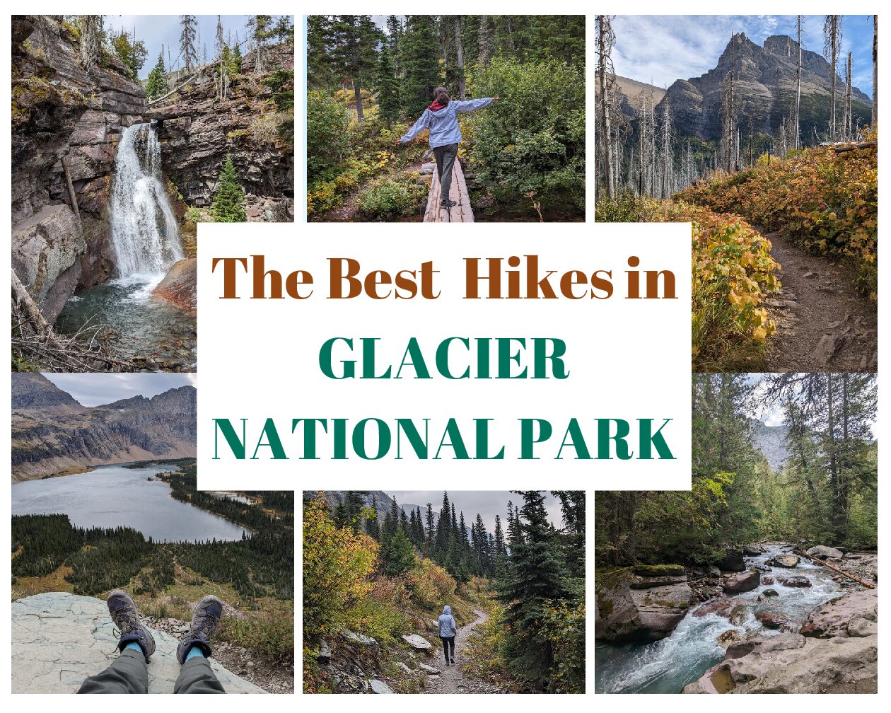
The Best Hikes at Glacier National Park: Glaciers, Lakes, and Waterfalls Oh My!
This post contains affiliate links. That means I may earn a small commission at no extra cost to you, if you buy through my site. I appreciate your support of my site.
Located in northwestern Montana, Glacier National Park should be at the top of your US national park bucket list because of the gorgeous landscapes and the scenic mountain drive on Going-to-the-Sun Road. While you’ll be able to admire a lot of the epic scenery from your car and the viewpoints, you’ll want to head out on the best hikes at Glacier National Park to really take in the magnificence of the glaciers, lakes, and waterfalls.
With multiple districts to choose from and over 700 miles of trails it really is quite difficult to pick the best Glacier National Park hikes. You need a lifetime of visits to hike all the trails! This post breaks up the top hikes in Glacier National Park by hikes in Lake McDonald, St Mary, Many Glacier, and Two Medicine. There are other districts in the park, but hiking one day in each of these districts gives you a great overview of the variety in the park and works well if you have 4 days in Glacier. I wrote about my favorite hikes and included a few other must do hikes in Glacier National Park that are on my list for my next visit.
Follow my 4 day Glacier Park itinerary for everything you need to know to plan your road trip including where to eat, where to stay, how to get around by car or shuttle, and other park FAQs.
The Best Hikes at Glacier National Park
Check the Glacier National Park trail map above for trailheads, parking, shuttle stops, and restrooms. Note that all of the following hiking stats are from the NPS and include round-trip distances.
Lake McDonald Hikes

The Lake McDonald district is located about a 10 minute drive from West Glacier. This western entrance to the park is usually open year-round. Many of the following Lake McDonald hikes are accessible in late spring and late fall, unlike the majority of the trails in the park.
The area includes the first 14 miles of the Going-to-the-Sun road. It’s home to the largest lake in the park, Lake McDonald, as well as several other beautiful lakes and trails through the woods.
Trail of the Cedars

Difficulty: Easy
Distance: .9 mile loop
Elevation Gain: 83ft
Elevation Loss: 83ft
Parking: At the Avalanche Creek Picnic area across the street from the trailhead. At the Avalanche Campground on the same side of the street, south of the trailhead. Pull in parking spots on the same side of the street, just north of the trailhead.
Shuttle Stop: West Side Shuttle – Avalanche Creek
Trailhead: Across the street from the Avalanche Creek Picnic Area
Restrooms: Toilets at the Avalanche Creek Picnic Area and the Avalanche Campground. Some of the campground restrooms are right off the western side of the trail.
If you are looking for easy hikes in Glacier National Park, the Trail of the Cedars is a popular choice. Located right off the Going-to-the-Sun road, it’s one of the last hikes in the Lake McDonald District.
Once you find a parking spot at this very crowded trailhead, you’re in for a relaxing stroll through an old growth forest. The short trail is accessible with the eastern side of the trail on a boardwalk and the western side on flat, packed dirt. About half-way around the loop you’ll cross over a footbridge with views of Avalanche Gorge. The Avalanche Lake trail junction is also in this area.
Avalanche Lake Trail

Difficulty: Moderate
Distance: 4.6 miles out and back
Elevation Gain: 741ft
Elevation Loss: 275ft
Parking: At the Avalanche Creek Picnic area across the street from the trailhead. At the Avalanche Campground on the same side of the street, south of the trailhead. Pull in parking spots on the same side of the street, just north of the trailhead.
Shuttle Stop: West Side Shuttle – Avalanche Creek
Trailhead: Begins from the Trail of the Cedars loop
Restrooms: Toilets at the Avalanche Creek Picnic Area and the Avalanche Campground. Rustic pit toilets off the trail to the right before reaching the lake.
The Avalanche Lake Trail junction is located about half-way on the Trail of the Cedars loop. Hike one side of the loop to the trailhead and hike the other side on your return.
After veering off from the Trail of the Cedars the terrain becomes rockier and steeper. You’ll soon be looking down at Avalanche Gorge. As you continue along the trail through the woods you’ll catch glimpses of the beautiful mountain backdrop.
The real highlight is the glistening turquoise lake at the end. The trail continues around one side of the lake. There are several short spur trails to walk right down to the lake’s edge. Bring a picnic lunch and savor the view from one of the many man-made benches. There are plenty of natural log or rock benches as well.
Apgar Bike Path

Difficulty: Easy
Distance: 3 miles total
Elevation Gain: 16ft
Elevation Loss: 0ft
Parking: At Apgar Visitor Center, along W Apgar Loop Rd
Shuttle: West Side Shuttle – Apgar Visitor Center
Trailheads: Apgar Visitor Center (there are other places that intersect the trail)
Restrooms: At Apgar Visitor Center. Apgar Campground and other businesses in the area also have restrooms.
I wouldn’t say the Apgar Bike Path is one of the must do hikes in Glacier National Park. I am including it for several reasons. First of all it is a paved trail making it accessible to strollers and wheelchairs.
It can be accessed directly from the Apgar Visitor Center which makes it convenient if you want to visit the center and do a bit more walking without having to drive to another trailhead. It’s perfect to do at the end of the day.
After only .4 miles from the visitor center the path intersects with Lake View Dr. While you can cross the road and continue on the bike path, you can also take a right along the road. Boat rentals, shops, restaurants, and Apgar Village Lodge are located here. The southern end of Lake McDonald is just past the businesses. Take a walk out onto the short boat deck for a great view of the lake.
Connecting with the Oxbow Trail is another option. This short 2 mile out and back trail runs along the McDonald Creek. It’s an easy, unpaved trail through the woods that is a great way to end your day hiking in Lake McDonald.
Other Lake McDonald Hikes
- John’s Lake Loop: Easy 2 mile trail that makes a wide loop around John’s Lake. No restrooms and only a few pull off parking spots are available. Closest shuttle stop is at Lake McDonald Lodge.
- Lake McDonald West Shore Trail: Moderate 14 mile out and back trail along the lake. Parking and restrooms at Fish Creek Campground on the southern end. Parking at Kelly Creek Camp on the northern end. No nearby shuttle stops.
- Apgar Lookout: Strenuous 7.6 mile out and back trail with a steady climb. Views of Lake McDonald and the surrounding peaks from the top. Parking at the trailhead, but no restrooms. No nearby shuttle stops.
St Mary & Logan Pass Hikes

Continue on Going-to-the-Sun road from the western side of the park in the Lake McDonald district to reach Logan Pass and St Mary. The zig zag road through the mountain peaks is one of the prettiest drives in the US. It leads to Logan Pass, which at 6646 ft is the highest elevation reachable by car in the park.
St Mary is the eastern gateway to the Going-to-the-Sun road. Many of the best hikes at Glacier National Park are within these high alpine areas. Any mountain lover won’t want to miss the following hikes.
Hidden Lake Overlook

Difficulty: Moderate
Distance: 2.6 miles out and back
Elevation Gain: 608ft
Elevation Loss: 128ft
Parking: Logan Pass Visitor Center has a large paved parking lot, but it does fill up early.
Shuttle: East & West Side Shuttle Stops – Logan Pass Visitor Center
Trailhead: Hidden Lake Trail behind Logan Pass Visitor Center
Restrooms: At the visitor center. They are open when the visitor center is not open.
As one of the most popular hikes in Glacier National Park, don’t expect to be alone for this one. The trail begins on a paved surface and quickly turns into a boardwalk across an alpine meadow. Before reaching the overlook the trail becomes gravel.
There is no shade and it can be quite windy depending on the weather conditions. Despite the steady climb, it is fairly gradual. When taking it slow there is plenty of time to soak in the mountain panoramas. In summer the meadow is full of wildflowers.
From the overlook you’ll be treated to a view of Hidden Lake below. Continuing on the Hidden Lake trail (described below) for another .5 miles or so gives you even better views of the lake. This part isn’t too steep.
Hidden Lake

Difficulty: Strenuous
Distance: 5 miles out and back
Elevation Gain: 639ft
Elevation Loss: 921ft
Parking: Logan Pass Visitor Center has a large paved parking lot, but it does fill up early.
Shuttle: East & West Side Shuttle Stops – Logan Pass Visitor Center
Trailhead: Hidden Lake Trail behind Logan Pass Visitor Center
Restrooms: At the visitor center. They are open when the visitor center is not open. A sign points to a short spur trail with a rustic pit toilet just before reaching the lake.
From the Hidden Lake Overlook continue on the same trail to hike all the way down to the lake. The next .5 miles is relatively flat and offers some nice views of the lake below from a different angle than the overlook.
The last .5 miles of the trail is a steep path down to the lake. The switchback trail leads to a short walk through the trees before reaching the lake’s edge. It is a nice spot for a picnic lunch or snack before making the arduous climb back up!
There are significantly less hikers after the overlook and a good chance of seeing wildlife. We saw a busy marmot digging around just off of the trail!
Three Falls Waterfall Hike

Difficulty: Moderate
Distance: 6.4 miles to & from Sun Point Trailhead
Elevation Gain: 762ft from Sun Point Trailhead
Elevation Loss: 640ft from Sun Point Trailhead
Parking: Jackson Glacier Overlook has pull out parking spots that are often full, but most people do not hike from this trailhead so there is quick turnover. Saint Mary’s Falls parking lot has space for about 20 cars and fills quickly. Siyeh Pass Trailhead has a few pull out parking spots. Sun Point Trailhead has the largest parking lot with the least amount of cars.
Shuttle Stops: East Side Shuttle – Jackson Glacier Overlook, East Side Shuttle – Saint Mary Falls, East Side Shuttle – Sun Point
Trailheads: Jackson Glacier Overlook, Saint Mary Shuttle Stop, Saint Mary’s Parking Lot, Siyeh Pass Trailhead, and Sun Point Trailhead
Restrooms: Trailhead pit toilets at Saint Mary’s Parking Lot and Sun Point Trailhead. Rustic pit toilet near the base of Virginia Falls.
You can go chasing waterfalls at Glacier National Park! Hike to not one, not two, but three waterfalls on the same hike! The trail stats above are for hiking from Sun Point Trailhead, but there are various ways to start this hike. It can be modified to only hike to one or two waterfalls as well. It’s a choose your own adventure depending on how far you want to hike, which waterfalls you want to see, and where you start.
The shortest option is from St Mary’s Falls. This works best if you are only planning to hike to Saint Mary’s Falls and Virginia Falls. You can easily turn around at the first falls as well. Starting from the Jackson Glacier overlook is the longest option and adds on about 5 miles round-trip. The Siyeh Pass Trailhead adds on about 2 miles roundtrip and Sun Point Trailhead adds on about 2.6 miles roundtrip, but both include Baring Falls. From the Saint Mary trailhead it’s a 1.6 mile detour to Baring Falls so it’s only about a mile longer to start from Sun Point to hike to all three falls.
Ultimately the best way to choose may be wherever you can find parking! While the lack of parking until Sun Point made the decision for us, I’m actually glad we started from that trailhead. The beginning portion along Saint Mary Lake is quite nice and not too busy.
All three falls are quite different, but all beautiful! The waterfalls are the main attractions along the trail, but the entire way the scenery is beautiful. Wherever you start, the Three Falls trek is definitely one of the best hikes at Glacier National Park!
Other Logan Pass & Saint Mary Hikes
- Highline Trail: Strenuous 14.9 mile out and back trail. The trail goes from the Loop to the Logan Pass Visitor Center. Both ends have parking, restrooms, and a shuttle stop if you wish to do the hike one way.
- Siyeh Pass Trail: Strenuous 9.8 mile out and back trail that is a good choice for alpine meadows and mountain scenery. Trailheads and parking at Piegan Pass, Jackson Glacier Overlook, and Siyeh Pass. It can connect with the Three Waterfalls Hike.
Many Glacier Hikes

It’s hard to choose the most beautiful part of the park. You really can’t go wrong anywhere, but Many Glacier has spectacular scenery. Full of high mountain hikes, the scenery can’t be beat. With sparkling lakes, meadows of wildflowers, glacier capped peaks, and gushing waterfalls, there is everything you could want for a picture perfect hike.
Grinnell Glacier

Difficulty: Strenuous
Distance: 10 miles out and back
Elevation Gain: 2,596ft
Elevation Loss: 1,015ft
Parking: A fairly large parking lot and street parking nearby. It is a popular trailhead and fills up fast. As most people park here for this long day hike, it’s hard to find a spot later in the day. Parking at the nearby lodges is another option if needed.
Shuttle Stops: The free park shuttle does not run in Many Glacier. A paid shuttle from Saint Mary Visitor Center goes to Swiftcurrent Motor Inn or Many Glacier.
Trailheads: Grinnell Glacier Trailhead. Take a Lake Josephine boat tour from Many Glacier Hotel and shorten the hike.
Restrooms: At the trailhead. Rustic pit toilets at the end of the trail before the final climb to the glacier.
Hikes to lakes and waterfalls have already been covered, it wouldn’t be a list of the best hikes at Glacier National Park without a hike to a glacier! There are two ways to do this hike. The hiking stats above are for the full hike from the trailhead.
To shorten the hike take a boat cruise across Swiftcurrent Lake and Lake Josephine. It’s a good way to combine a boat trip and a hike. While it will save you about 3.2 miles round-trip, this part of the trail is fairly flat through a forest. You’ll be missing the easiest part of the trail. The quiet peace of the forest with lake views all along the walk was relaxing, but I’m sure a boat ride would be just as nice.
Whether you arrive on foot or by boat, once you’re at the end of Lake Josephine your climb will begin! It’s pretty much uphill all the way to Grinnell Glacier. It’s not just about the destination, the Glacier, but all the incredible views along the way. I loved looking down at the emerald waters of Grinnell Lake while admiring the glistening glaciers high above.
It can be daunting to see your final destination so far ahead and you may need to stop to catch your breath often. Luckily you’ll want to break frequently to take in the scenery. It just keeps getting better and better the higher you go. There’s a good chance of seeing wildlife too. There were a lot of mountain goats, including a baby and adult only a couple of feet off the path.
Other Many Glacier Hikes
- Cracker Lake: Strenuous 12.2 mile out and back hike to an alpine lake with amazing views along the way. Large parking lot, shuttle stop at Many Glacier hotel, toilets at the trailhead, and rustic pit toilets at the end of the trail.
- Redrock Falls: Easy 3.7 mile out and back hike to a waterfall. Parking, shuttle stop, and restrooms at the trailhead (Swiftcurrent Trailhead).
- Iceberg Lake: Strenuous 9.6 mile out and back hike with an alpine lake and fantastic scenery. Same Swiftcurrent Trailhead amenities as well as additional parking. Rustic toilets along the trail at Ptarmigan Falls and Iceberg Lake.
- Apikuni Falls: Moderate 1.8 mile out and back waterfall hike. No restrooms, no shuttle stop, but with a few pull off parking spots.
Two Medicine Hikes

Out of all the Glacier NP districts, this one may be the least visited. It’s one of the reasons I really enjoyed hiking in Two Medicine. The most popular hikes are popular for a reason, but there is truly something special about being out in the woods alone.
With fewer hikers, it’s a good chance to spot some wildlife. We saw a deer and a moose here. I thought for sure we would glimpse a bear, but unfortunately, or fortunately depending on how you look at it, we didn’t! Avoid hiking alone and make noise as you hike!
Don’t let the lack of crowds fool you, it’s still a gorgeous region to hike with waterfalls, lakes, and mountain vistas! Almost all of the Two Medicine hikes are connected which allows you to choose your own loop hikes with optional extensions. A boat shuttle travels across Two Medicine lake which can reduce your total hiking mileage.
Rockwell Falls

Difficulty: Moderate
Distance: 6.6 miles out and back
Elevation Gain: 537ft
Elevation Loss: 284ft
Parking: Large parking lot at the South Shore Trailhead. A few spots at the North Shore Trailhead, but most of the parking is for camping.
Shuttle Stop: No shuttles to Two Medicine.
Trailhead: South Shore Trailhead (or North Shore Trailhead if hiking a loop)
Restrooms: At the trailheads. If hiking a loop there is a pit toilet between Rockwell Falls and Twin Falls.
Rockwell Falls is located along the South Shore Trail. The hike is rated moderate mostly for the distance as the elevation change is fairly gradual. With sections through pine and fir trees and across meadows, the scenery is beautiful. The surrounding mountain peaks provide the perfect backdrop.
A side trail leads to Aster Falls and Aster Falls Overlook, mentioned below. A suspension bridge over Paradise Creek makes some hikers nervous. Between catching my breath and taking photos I rarely need to pass other hikers, but one hiker needed a lot of encouragement to cross the bridge! On the other hand, I loved it! There are a few other narrow, but sturdy wooden bridges.
The falls aren’t huge, but tucked within the trees they are magical. There are some nice rocky seats at the base for admiring it. The falls seemed extra lovely to me as we had them all to ourselves…..except for those nasty little ground squirrels! They are everywhere at Glacier and are fearlessly after your food.
After the falls go back the same way to the trailhead. For a longer 10.5 mile clockwise loop hike, combine this trail with Twin Falls, described below. To hike the loop take a left when you come to the first T in the trail. On the way to Twin Falls, you’ll have wide open views of Lake Josephine on your right.
Twin Falls

Difficulty: Easy
Distance: 7.2 miles out and back
Elevation Gain: 485ft
Elevation Loss: 381ft
Parking: Large parking lot at the South Shore Trailhead. A few spots at the North Shore Trailhead, but most of the parking is for camping.
Shuttle Stop: No shuttles to Two Medicine.
Trailheads: North Shore Trailhead (or South Shore Trailhead if hiking a loop)
Restrooms: At the trailheads. If hiking a loop there is a pit toilet between Rockwell Falls and Twin Falls.
Beginning from the North Shore Trailhead, the first couple of trail miles to Twin Falls are along Two Medicine Lake. The wide unobstructed views of the surrounding peaks are fantastic.
Towards the end of the lake, the trail veers away into a wooded area. Be on the lookout for wildlife along the trail. A sign points to the short spur trail to Twin Falls. As you might guess the falls are two separate falls that converge at the bottom. It’s a good spot for a picnic.
For a longer 10.5 mile loop hike combine this trail with Rockwell Falls, described above. Hiking farther past Twin Falls to Upper Two Medicine Lake, mentioned below, is another option.
Not only is this one of the best hikes in Two Medicine, but one of the best hikes in Glacier National Park overall to avoid the crowds while enjoying the awesome scenery.
Other Two Medicine Hikes
- Aster Falls: Easy 2.6 mile out and back hike to a 20ft falls. It’s a .2 mile round trip detour on the way to Rockwell Falls.
- Aster Park Overlook: Moderate 3.8 mile out and back hike to an overlook with panoramic views of Two Medicine Valley. Aster Falls is on the way.
- Upper Two Medicine Lake: Moderate 9.4 mile out and back hike past Twin Falls, through meadows, and to the glacially fed Upper Two Medicine Lake.
- Pitamakan-Dawson Pass loop: Strenuous 18.8 mile loop trail that can be done as a very difficult day hike or as part of a backpacking trip. It begins from the North Shore Trailhead.
- Running Eagle Falls: Easy .6 mile out and back trail to a waterfall that is not connected to the rest of the Two Medicine hikes. Parking lot and pit toilets at the trailhead.
Before heading out on the best hikes at Glacier National Park, remember to read my full Glacier National Park guide. If I helped you discover the best hiking in Glacier National Park, please consider supporting me by Buying Me a Coffee.
More About Montana
- A 4 Day Glacier National Park Itinerary for Adventurers
- The Best Places to Eat in Helena
- Fun Things to Do in Helena
- Indoor Things to Do in Great Falls
Pin IT!!


You May Also Like
The Best Hikes in Bryce Canyon National Park Along the Shuttle Route

My Walk Through Ice & Fire with Icelandic Mountain Guides