
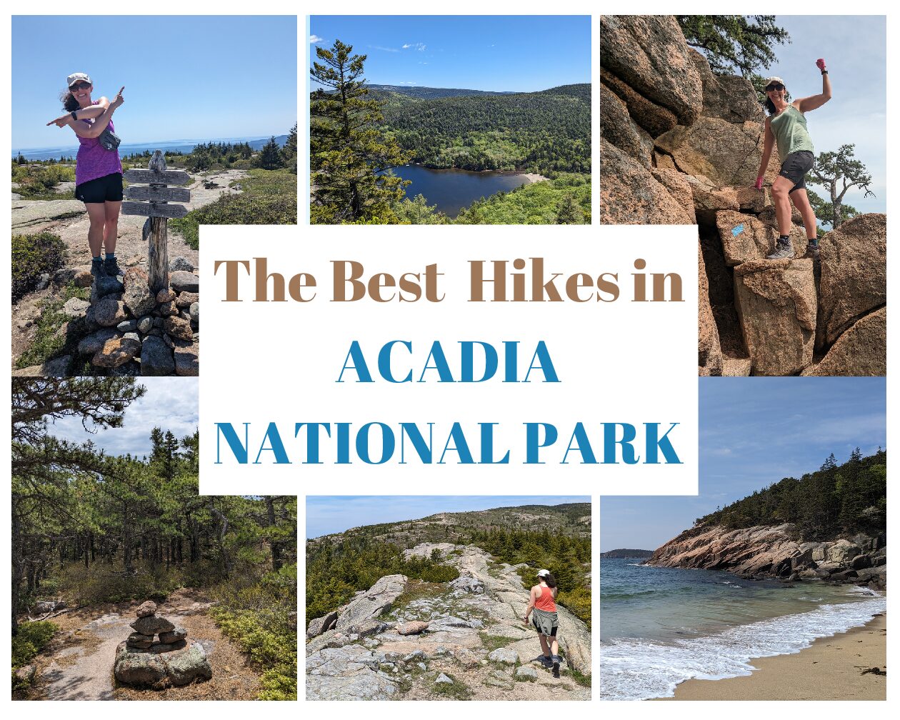
The Best Hikes in Acadia National Park
This post contains affiliate links. That means I may earn a small commission at no extra cost to you, if you buy through my site. I appreciate your support of my site.
The crown of the continent might be Glacier National Park in Montana, but Acadia National Park is the crown “jewel” of the North Atlantic Coast! It should definitely be on your US National Park bucket list. Located along the rocky coastline of Maine on Mount Desert Island, Acadia NP offers the perfect combination of mountains, forests, and the Atlantic Ocean.
With more than 150 miles of trails, there are plenty of ways to enjoy the landscapes and seascapes at Acadia. Many of the best hikes in Acadia National Park combine mountain, forest, and ocean views. The following Acadia hikes range from easy to hard and include a variety of scenery.
Before heading out on the best hikes in Acadia you’ll want to be prepared with your hiking attire and what to bring in your daypack. Wondering about how to get around Acadia with the Island Explorer, where to find the best lobster roll, and where to stay in Acadia? For more information to help you plan your visit to Acadia and for more places to explore in Maine, read my Maine road trip.
The Best Hikes in Acadia National Park
This Acadia National Park trail map groups trails by location. The stats below are from AllTrails and the NPS.
Sand Beach Trails

Trails at Sand Beach: Ocean Path, Beehive Trail, Great Head Trail
Parking: Paved parking lot with 101 spaces at Sand Beach. During peak times of the year it is very busy from 10am – 2pm.
There are smaller parking lots at Thunder Hole, Otter Cliff and Otter Point.
Shuttle Stop: Island Explorer #3 and #4 includes stops at Sand Beach, Thunder Hole, and Otter Cliff.
Restrooms: Restroom building in the Sand Beach parking lot. There are also restrooms at the Thunder Hole parking lot.
As the name implies Sand Beach is a sandy stretch of coastline with a small, sand beach. It is a great place to take a dip in the water or sit on the rocks for a picnic. Be aware that chipmunks may want to join you for your lunch. As I visit more and more national parks it seems like they are the official park mascots…..especially wherever food is involved! Everyone worries about bears, but my most troublesome wildlife encounters are always with those darn chipmunks.
Several of the best hikes in Acadia National Park start from the beach or the parking lot.
Ocean Path

Difficulty: Easy
Distance: 4.4 miles out and back
Elevation Gain: 374ft
Trailhead: Sand Beach parking lot (there are many other access points along the path)
One of the best easy hikes in Acadia National Park is the Ocean Path. From Sand Beach the trail travels along the coastline for 2.2 miles until Otter Point. As an out and back trail you can turn around at any point or access the path from different points including Thunder Hole. The concrete and gravel trail from Sand Beach to Thunder Hole is accessible.
Thunder Hole is one of the most popular viewpoints along the way. Due to the unique rock formations and cliff walls, the ocean waves coming into the channel create a build up of water. During storms and high tide the water sprays out and makes a roaring sound. It’s best to time your hike to arrive at Thunder Hole one to two hours before high tide as that is when the water sprays are likely to be the highest and the water’s “roar” the loudest.
After Thunder Hole the trail becomes more uneven and has some rocky sections and stairs. While the viewpoints along the path are similar, they are so fantastic that I thought it was worth it to hike the entire path. Thunder Hole is a cool spot, but I actually found spots in between the official viewpoints to be the best. It was similar views, but we could have them all to ourselves.
Beehive Trail

Difficulty: Hard
Distance: 1.5 mile loop
Elevation Gain: 508ft
Trailhead: Sand Beach – from the parking lot walk across Park Loop Rd to the Bowl/Beehive Trailhead.
While iron rungs, ladders, and rock scrambling aren’t exclusive to hikes at Acadia, this national park has a lot more than other national parks. Other hikes might have an iron rung or a ladder in one spot, but several Acadia hikes are full of them. The Beehive Trail is one of the best hikes in Acadia National Park for a challenging, yet really fun hike with scrambling and iron rungs.
The trail begins on the Bowl Trail which is full of mid-sized loose rocks. As there is very little incline in this section there is no scrambling required. Ironically this was the hardest part of the hike for me, but I think I am in the minority with that!
When you reach the trail junction for the Beehive Trail go counterclockwise (to the right). For most people this is when the challenge begins. For me it was when the fun really started! Keep an eye out for the blue blazes as with all the rock scrambling it can be easy to lose track of the trail.
I couldn’t get enough of the rock scrambles and pulling myself up with iron rungs. I’m usually about ready to collapse by the time I reach a summit, but I wanted this trail to keep going. Although there are steep drop offs, being able to have secure hand holds made all the difference compared to traversing across sandstone in Utah on the Devils Garden Trail when there were no hand holds. Apparently I am much more comfortable on all fours! For those of you who are afraid of heights or hiking with children, you may want to skip this hike. Also avoid this hike in wet weather.
Once at the top you’ll be able to calm your nerves and enjoy the fantastic panoramic views. Continue on the loop trail to The Bowl, a peaceful pond and through the wooded trail to the trail junction where you initially turned right. No scrambling or iron rungs are part of the descent. To finish, hike the same rocky .2 miles section that you started with.
For a longer hike, connect with the Gorham Mountain Trail or the Champlain S Ridge Trail.
As I recommended in my hiking attire post, wearing lightweight grippy gloves is very helpful for hikes like this!
Cadillac Mountain Trails

Do you want to see the sunrise before anyone else in the USA? The first place the sun hits is the top of Cadillac Mountain, the highest point in the eastern seaboard. You’ll need a coveted vehicle reservation and a very early wake up call, but you’ll be rewarded with a stunning sunrise on most mornings.
It’s the only mountain in the park that, with a reservation, is accessible by vehicle. If you don’t have a vehicle reservation or want more of a challenge, you can reach the summit on foot in many different ways. The Cadillac North Ridge and the Cadillac South Ridge trails are the most common routes.
Cadillac Mountain Summit Loop

Difficulty: Easy
Distance: .5 mile loop
Elevation Gain: 55ft
Trailhead: Cadillac Summit
Trails at this Trailhead: Cadillac Summit Loop, Cadillac South Ridge Trail (labeled Middle Peak Rd on some maps), Cadillac North Ridge Trail, and Gorge Path. These trails connect to several other trails.
Parking: Vehicle reservations are required from Mid-May to Mid-September to drive Cadillac Summit Road and park in the paved lot at the summit. Parking without reservations is available for the South Ridge and North Ridge trails at the bottom of the mountain.
Shuttle Stop: No Island Explorer stop at the top of the mountain.
Restrooms: Restroom building next to the gift shop at the summit.
Arriving at a trailhead by early morning is enough of a challenge for me so I unfortunately missed out on sunrise at the summit, but I did hike the Cadillac Summit Loop later in the day. Let me tell you, the views are still spectacular during the day. Sunset is also a popular time of day to visit.
From the short loop trail there are magnificent views of the coast and nearby islands. Sections of the trail near the parking lot are paved and accessible. Other sections are uneven and rocky or require hiking up or down stairs. Although it is one of the most popular hikes in Acadia, there are plenty of rocky spots to spread out and enjoy the view.
Cadillac South Ridge Trail

Difficulty: Moderate
Distance: 6.7 mile out and back
Elevation Gain: 1,548ft
Trailhead: Cadillac South Ridge Trail (3 starting points)
Other Trails at This Trailhead: Quarry trail from the Blackwoods Campground that connects with other trails.
Parking: Side of the road parking spots on ME – 3. If camping at Blackwoods Campground you can park one vehicle and park in the overflow parking spots in the A-Loop.
Shuttle Stop: Island Explorer #10 stops at the Blackwoods campground. Island Explorer #4 and #5 stop at Cadillac N Ridge for the Cadillac North Ridge Trail.
Restrooms: No restrooms at the trailhead. Restrooms at the Blackwoods campground. There is a restroom building at the summit.
No vehicle reservation? No problem! You can hike to the top of Cadillac Mountain. While the top of the mountain is full of people, we saw very few other hikers while on the South Ridge Trail.
We chose the South Ridge Trail over the North Ridge Trail at the recommendation of a park ranger. He said the elevation gain was more gradual and the views were better. As the trail isn’t as steep, the trail is longer. We started from ME – 3 (a paved road for vehicle traffic). The total mileage in the stats above is calculated from the start in the Blackwoods campground.
The trail begins in a forested area and eventually becomes more exposed along a granite ridgeline. As you climb out of the forest the views will open up to the Atlantic Ocean!
Overall the moderate rating comes from the length of the trail and not the elevation gain or the terrain. There are only a couple of short sections of rock scrambling before reaching the summit. The trail is fairly easy to follow. When in doubt look for the blue blazes or cairns (rock piles).
At the summit, hike the loop trail (described above) and take in the views you worked so hard to reach. While you can drive to the top, views always look better when you work harder to reach them!
Return on the South Ridge Trail the same way you came. If you have multiple vehicles, can take the Island Explorer, or want an even longer trail choose one of the many other connecting trail options.
Jordan Pond Trails

Trailhead: Jordan Pond (or Bubbles Divide)
Trails at Jordan Pond: Jordan Pond Path, Jordan Stream Carriage Rd, Jordan Wildwood Carriage Rd, and Spring Trail. Those trails connect to many other trails including Jordan Cliffs Trail, Bubbles Divide Trail, Penobscot Mountain Trail, and the Sargent trails.
Parking: Two large, paved parking lots off of Park Loop Road. There are 152 parking spots and 12 oversized parking spots within the two lots. One is near the Jordan Pond Restaurant and one is at the boat launch.
To the northeast of Jordan Pond the Bubbles Divide trailhead has a small parking lot for about 15 cars.
Note that all the mileage under each trail starts from the Jordan Pond House.
Shuttle Stop: Island Explorer #4, #5, #6 stops at Jordan Pond.
Restrooms: Vault toilet at the boat dock parking lot and full restrooms at the Jordan Pond Restaurant. Vault toilet at Bubbles Divide trailhead.
Many of the best hikes in Acadia National Park are around Jordan Pond. Jordan Pond is a beautiful, pristine lake that is surrounded by mountains. It’s a popular area of the park full of trails that go around the lake and up the different mountain peaks. Most of the parking is to the south of Jordan Pond, but you can also start from Bubbles Divide.
Not including the spectacular scenery, one of the best parts of hiking in Acadia is that the trails are very interconnected. While many of the trails are out and back, there are so many trail junctions that you can hike in various ways.
We did one big 5.8 mile loop. To begin we hiked a short distance on the southernmost Jordan Pond Path from the Jordan Pond boat launch to the Jordan Stream Carriage Road. We then turned right onto the Spring Trail. As the Jordan Cliffs Trail was closed for peregrine falcon nesting we headed up the Penobscot Trail. We continued on the Sargent South Ridge trail to Sargent Peak. For variety we should have taken the Sargent East Ridge Trail back down, but we retraced our steps until we reached the trail junction to go left on Deer Bark Trail instead of backtracking down Penobscot Trail. We met up with the Jordan Pond Path at the north end of the park where we trekked back to the start along the western side. These trails are described in more detail below.
Whichever hikes you choose, stop in at the Jordan Pond House for a warm popover afterwards!
Jordan Pond Loop

Difficulty: Easy
Distance: 3.4 mile loop including the distances to/from the south end of the lake to start the loop.
Elevation Gain: 42 feet
The Jordan Pond Path is one of the first trails you’ll reach from the parking lots. The loop is the trail that literally goes around the lake. The views of the lake are excellent from all vantage points. It can be done as a full loop on its own or easily combined with any of the other hikes in the area (see below). We finished off our big hike by hiking from the north to the south side of the lake along the western side.
I always find the official trail difficulty ratings to be a bit arbitrary. There are so many factors that go into how difficult someone finds a trail. The Jordan Path Loop is marked easy, but don’t expect a smooth flat trail the entire path. While the trail doesn’t have much elevation change, is never along steep drop-offs, and isn’t along an ocean coastline with rip tides ready to pull you out to sea, just be aware that there are some rocky sections. You’ll want to keep an eye on your kids and be prepared for uneven footing so you don’t take a fall or a dip in the lake! Note that swimming is not allowed in the lake.
Jordan Pond Carriage Roads

Difficulty: Easy
Distance: Varies
Elevation Gain: Varies
Thanks to John D Rockefeller Jr there are 45 miles of carriage roads in the park. He created these horse and carriage roads for visitors to explore without cars. If only we were so lucky to have Acadia be car-free to this day! Thankfully the carriage roads are still car-free and open to horses, bicyclists, and pedestrians.
If you’re looking for easy hikes in Acadia, the carriage roads are a great option. The fairly flat and wide gravel or paved paths offer a relaxing and more accessible way to enjoy the beauty of the park. Look out for the historic bridges from 1917 to 1940.
Many miles of carriage roads can be found around the lake. The Jordan Stream Carriage Road forms a 1.7 mile loop that starts from the Jordan Pond House, gives you a peak of the lake from the southern end, and continues on a forested path to the south.
Carriage roads also serve as great connectors to other hiking trails.
Spring Trail

Difficulty: Moderate
Distance: 1.2 miles out and back
Elevation Gain: 140ft
The Spring Trail connects the Jordan Pond House with the Penobscot Mountain trail. The trail intersects with the Jordan Cliffs Trail and the Amphitheater East Carriage Road.
Most of the trail is a gradual incline or climb on stone stairs in the forest. My favorite part was the small section that required a bit of rock scrambling.
Penobscot Mountain Trail

Difficulty: Moderate
Distance: 2.8 miles out and back including the Spring Trail
Elevation Gain: 974ft
From the Spring Trail continue the climb to Penobscot Peak. Most of the trail is on a granite slope. There are some trees, but it is mostly exposed. This can mean it can get quite hot in the summer, but the views are excellent.
The peak is clearly marked with a large rock pile and trail sign. Panoramic views give you the lay of the land and the sea in all directions.
Sargent S Ridge Trail

Difficulty: Moderate
Distance: 4.8 miles out and back including the Spring Trail & Penobscot Trail.
Elevation Gain: 1,318ft
There are many ways to reach Sargent Peak. The stats above are from starting at the Jordan Pond House and with the route of trails I have been describing above. Note that we didn’t return back the same way.
We hiked the Sargent S Ridge Trail from Penobscot Peak. A shady forest awaits you after a short hike down from Penobscot Peak. Shortly after, the climb up Sargent Mountain begins with some rock scrambling. Along the way Sargent Mountain Pond, a slightly secluded, tranquil pond, is worth a stop.
After the pond you’ll need to do some more rock scrambling before the trail opens up to another, exposed granite slope. It was very windy on the day we visited. We struggled much more with the strong winds than the climb.
Like Penobscot Peak, Sargent Peak is marked by a trail sign and large pile of rocks. The 360 views are worth the climbing and battling of the wind!
Deer Bark Trail

Difficulty: Moderate
Distance: 4.4 miles out and back including the Spring Trail & Penobscot Trail
Elevation Gain: N/A
Unlike other national parks, Acadia doesn’t provide newspapers with trail maps and descriptions. We had planned to hike the Spring Trail to the Jordan Cliffs Trail. As we found the trail closed when we arrived we needed to come up with a new plan. We continued on the Spring Trail to Penobscot Peak.
Thanks to a fellow hiker who let us look at her official trail map she had purchased, we came up with a new route to Sargent Peak. As I said above, after we reached the peak we retraced our steps back down the Sargent South Ridge Trail until we turned left on the Deer Bark Trail. If we would have had a map with us or had a plan ahead of time we would have taken the Sargent East Cliffs Trail to the Deer Bark Trail.
However you reach the trail, Deer Bark Trail is a nice forest trail. There isn’t any scrambling, but a lot of the trail is rocky. Deer Brook Bridge is one of the many historic carriage road bridges in the park. You’ll hike across the road and see this double arch bridge from below.
From the bridge take the Eagle/Jordan Carriage road or continue on to the Jordan Pond Loop that will lead you back to where you started!
Jordan Cliffs
Difficulty: Moderate
Distance: 1.7 miles one way including the Spring Trail (additional mileage is needed to complete a loop back to the start)
Elevation Gain: N/A
I’m making an exception to my rule about never writing about something unless I have personally experienced it and truly recommend it. Unfortunately I wasn’t able to do the Jordan Cliffs trail because it was closed for peregrine falcon nesting.
While I really enjoyed the other trails we did instead (described above), I was disappointed to miss out on this one as it is one of the best hikes in Acadia. Jordan Cliffs is a challenging hike that includes large boulders, narrow ledges, bridges, ladders, and iron rungs. Of course there are amazing views as well.
The trail starts from the Spring Trail and ends at the junction of the Deer Bark Trail and the Sargent E Cliffs Trail. It’s recommended to go one way. Before returning you can make a longer loop by hiking the peaks I wrote about above in reverse and ending with the spring trail back to the Jordan Pond House. For a shorter loop take Deer Bark Trail to the Jordan Pond Loop.
Echo Lake Beach Trails

Trails at Echo Lake Beach: Beech Cliff Trail and Canada Cliffs Trail. Those trails connect to other trails including Beech Mountain Trail, Valley Trail, Beech S Ridge Trail, and Beech W Ridge Trail.
Parking: 89 paved parking spots. The lot is very busy in the summer from 8am – 4pm.
Shuttle Stop: Island Explorer #7 stops at Echo Lake
Restrooms: Restroom building with flush toilets near the beach.
Sand Beach is the place to go for saltwater swimming and Echo Lake is the best freshwater beach in Acadia. Surrounded by trees and mountains it’s a picturesque area.
At the end of May the beach was packed with sunbathers. Despite the chilly water temperature, there were quite a few swimmers as well. Several hikes at Acadia start or connect to trails that start from the Echo Lake parking lot.
Beech Cliff & Canada Cliff Loop

Difficulty: Moderate
Distance: 2 mile loop
Elevation Gain: 492ft
Trailhead: Echo Lake Beach parking lot
For the best view of the beach, leave the packed beach behind! Hike the Beech Cliff trail and the Canada Cliffs trail as a loop to admire the beach from above! Start going counterclockwise, to the right, from the parking lot.
The trail begins in the woods and includes a few switchbacks. Not too far into the hike a trail sign marks the way to an overlook. If you only want a short hike or want to avoid the ladders you can hike to the overlook for your first great views of the beach. Even if you’re planning to complete the full loop, don’t overlook the overlook!
As you continue on the trail you’ll reach several ladders. Beech Cliff is one of the best hikes at Acadia if you want the perfect mix of a fun Acadia hike, aka ladders, but don’t want narrow paths along steep drop offs. The ladders are very sturdy and are not along ledges. It’s always fun to have a little something different thrown into a hike! It’s best to hike the trail counterclockwise so all hikers are going the same direction, up the ladders.
There are no ladders on the Canada Cliffs trail back down to where you started. Before heading back down through the forest trail, enjoy the many vantage points at the top. The additional short Beech Cliff loop within the big loop hike is worth the short detour too.
Up for a longer hike? Add in the Beech Mountain trail for an additional loop.
Other Hikes in Acadia
It’s very hard to choose the best hike in Acadia National Park. Here are two more Mount Desert Island hikes in Acadia.
Bar Island Trail

Difficulty: Easy
Distance: 1.9 mile out and back
Elevation Gain: 187 ft
Trailhead: Bar Harbor
Parking: Designated parking lots or street parking. You need to pay for both, but street parking is cheaper. Park along West St for the start of the Bar Island Trail.
Shuttle Stop: Island Explorer #1, #2, #3, #6, #7, #9, #10, and #12 stop in the Bar Harbor Village Green. The #13 Bicycle Express also stops in Bar Harbor.
Restrooms: Public restrooms across from Agamont Park.
For all the hikes in Acadia you want to be careful, but you need extra precaution when hiking the Bar Island Trail. You might be surprised that one of the easiest Acadia hikes needs an extra warning, but that is because of the tide. You can only hike this trail 1.5 hours before and 1.5 hours after low tide. The hike will become a “swim” at other times! In case you couldn’t figure it out, I am demonstrating that in the picture above!
The hike begins from Bridge Street in downtown Bar Harbor and goes across the bay on a gravel path to Bar Island. Essentially a land bridge during low tide, the path allows you to visit Bar Island on foot. Once on Bar Island, hike the short trail into the forest. Views of Bar Harbor open up at the peak.
Back down on the beach, several fallen logs provide a nice place for a break. It’s also fun to walk along the shore on different sides to check out the sealife. Whatever you do, don’t lose track of time or you’ll be paying an expensive water taxi to get you back to the mainland!
Precipice Loop
Difficulty: Hard
Distance: 1.8 mile loop
Elevation Gain: 1,059ft
Trailhead: Precipice Loop
Other Trails at this Trailhead: Murphy Lane is across the street.
Parking: Paved lot with about 20 spaces.
Shuttle Stop: No stop, but you can ask the driver to stop or flag down a bus on routes #3 or #4.
Restrooms: No
Precipice Loop was one more trail I wasn’t able to do because it was closed for peregrine falcon nesting. As another one of the best Acadia National park hikes I needed to break my rule again to be able to recommend it!
The Precipice Loop could be considered the big brother to the Beehive Loop. If it’s your first time with rock scrambling and iron rungs you might want to do the Beehive hike first. This challenging hike is not for the faint of heart. Iron rungs and ladders fill the trail. The narrow ledges add to the fun…..or the fear, depending on what kind of hiker you are!
It’s a non-technical hike, but it does involve a lot of scrambling and being able to stay on the trail. Make sure to hike the trail clockwise. You’ll go left at the first junction. You’ll hike Champlian Ridge North Trail and the Orange & Black path to return to the starting point.
What are you waiting for? It’s time to go hiking in Acadia now! If I helped you discover the best hikes in Acadia National Park please consider supporting me by Buying Me a Coffee!
More About New England
- The Only Maine Road Trip You Need (Maine)
- The Best Indoor and Outdoor Things to Do in Portland (Maine)
- All of the Historic Boston Freedom Trail Stops (Massachusetts)
- Historical Sites in Rhode Island to Learn the History of the Ocean State (Rhode Island)
Pin IT!!


You May Also Like

The Best Hiking Near Atlanta

A Hiker’s Southwest Colorado Road Trip